
If you have any questions, you are always welcome to contact us. We'll get back to you as soon as possible, within 24 hours on weekdays.
-
Shipping Information
We offer reliable shipping across the United States. Orders over $599 qualify for free standard shipping.
Shipping options and estimated delivery times are shown at checkout and may vary by product and destination.
Products containing lithium-ion batteries may be subject to special shipping and carrier requirements.
For large equipment or enterprise orders, please contact our sales team for shipping assistance.
-
Customer Support
Need help choosing the right product, checking an order, or troubleshooting a product?
Our team can assist with product selection, order status, shipping, warranty, technical support, and general product questions.
Sales & Product Inquiries
Phone: +1 (888) 356-6818
Email: sales@droneroboticstec.comTechnical Support
+1 (888) 356-6818 Ext. 804 — Christopher
+1 (888) 356-6818 Ext. 806 — LucasWorking Hours
Mon–Fri: 9:00 AM–5:00 PM PST -
Contact Us
Have a question before placing an order?
Contact our sales team for product recommendations, availability, pricing, enterprise solutions, and bulk orders.
Sales Team
Phone: +1 (888) 356-6818
Email: sales@droneroboticstec.comFor enterprise, commercial, bulk, or dealer inquiries, we're happy to help you find the right solution.
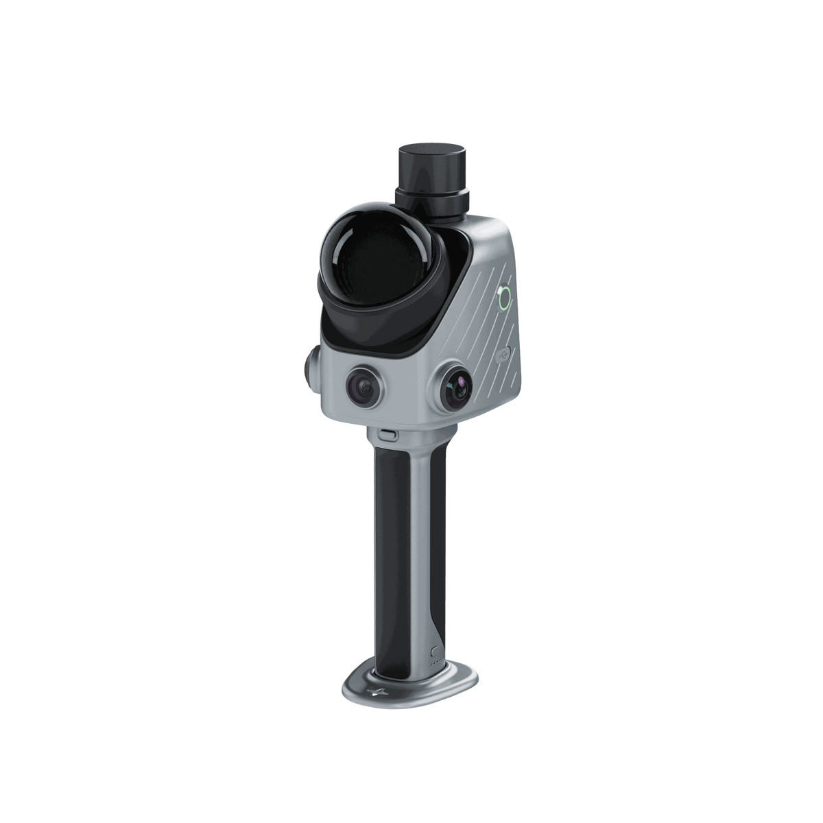
FJD Trion X1 3D Handheld LiDAR Scanner
A handheld 3D LiDAR reality capture system designed to help teams plan, capture, document, and review real-world conditions with a guided field workflow.
Start with what needs to be captured
Sending someone onsite is easy. Making sure they capture the right data is harder. With X1, teams can define a specific capture task before deployment, guide the operator through the field workflow, document issues and observations, and bring the captured information together for review and reporting.

From Physical Space to 3D Data
X1 connects task planning, guided field capture, issue documentation, and project review into a traceable reality capture workflow.
Plan
Define what needs to be captured in FJD Trion Model Web before the site visit.
Capture
Follow guided instructions and capture 3D spatial data directly onsite.
Document
Mark issues and add field observations while the scan is being captured.
Review
Bring scans, issue markers, route data, and observations together for review and reporting.
How X1 Keeps Every Task on Track
X1 combines LiDAR scanning, 360° imaging, GNSS support, a built-in display, and guided workflows to simplify field data collection and improve consistency across projects.

Set the Standard Before the Site
Define the capture area, route, and priorities in FJD Trion Model Web, then sync the task to X1 for field execution.

Follow the Task in the Field
Use onscreen route guidance while capturing the site, helping operators follow the planned workflow without relying on separate instructions.

Mark Issues in the 3D Record
Use the crosshair during scanning to mark an issue and associate it with its location in the captured 3D data.

Add Context with Voice Notes
Record field observations by voice. Model Web can transcribe supported languages for review and reporting.

From Field to Result
Bring scans, issue markers, route data, and field observations together in Model Web for review, sharing, and reporting.

One Device for Field-Ready Reality Capture
X1 integrates GNSS, LiDAR, 360° imaging, and a built-in screen in one handheld system, with support for an external microphone.

See the Work While You Capture It
The built-in display lets operators see where they are aiming and what they are capturing directly on the device.
Built for Repeatable Reality Capture
X1 is designed for teams that need consistent 3D records across multiple sites, operators, and field assignments.
As-Built Verification
Capture construction progress, renovation conditions, MEP installations, and as-built 3D records for project documentation and verification.
Forensic & Incident Scenes
Create 3D and panoramic scene records for incident documentation, safety records, and investigation workflows.
Urban Tree Management
Capture 3D records of urban trees, campus roads, green belts, landscape assets, and surrounding environments.
Material Yards & Stockpiles
Create 3D volume records for stockpiles and material yards with GNSS-assisted positioning.
Software Built for 3D Project Work
X1 works with the FJD Trion software ecosystem to support project coordination, online collaboration, point cloud processing, and reporting.
FJD Trion Model Web

A browser-based workspace for X1 projects, supporting project setup, 3D data processing, project management, online collaboration, and reporting.
FJD Trion Model

Professional point cloud processing software for detailed editing, analysis, and refinement of 3D scan data on PC or tablet.
Built for Detailed 3D Capture
*Lab-tested accuracy. Actual results may vary depending on environment, workflow, and operating conditions.
X1 Specifications
Detailed specifications for the FJD Trion X1 3D Handheld LiDAR Scanner.

| Point Rate | 384,000 pts/s |
| Scanning Range | 40 m @ 10% reflectivity 70 m @ 80% reflectivity |
| Post-Processing Accuracy* | Relative: ±1 cm Absolute: ±3 cm |
| Field of View (FOV) | 360° × 62° |
| Eye Safety Rating | Class 1 |
| Front Camera FOV | 80° × 44° |
| Front Camera Resolution | 1280 × 1024 |
| Panoramic Cameras FOV | 360° × 360° |
| Panoramic Camera Resolution | 2 × 48 MP |
| Visual SLAM | Supported |
| Image Export | Supported |
| Image Format | JPG |
| Screen | 3.9-inch OLED |
| Screen Resolution | 1280 × 1024 |
| Battery Life | Up to 5 hours with one set of two batteries |
| Power Supply | DC handheld battery |
| Power Consumption | Approx. 18 W |
| Charger | 67 W fast charging |
| Simultaneous Dual-Battery Charging | Supported |
| Dimensions | 114 × 152 × 329 mm |
| Weight | Main Unit: 900 g Full Setup: 1.3 kg |
| Storage | 512 GB, expandable to 1 TB |
| Operating Temperature | −20°C to 50°C |
| Storage Temperature | −40°C to 60°C |
| Ingress Protection | IP54 |
| Data Export | Wireless Network USB Type-C USB Flash Drive |
| Point Cloud Formats | LAS, PLY, PTS, E57 |
*Lab-tested accuracy. Actual results may vary depending on environment, workflow, and operating conditions. Specifications are subject to change without notice.