

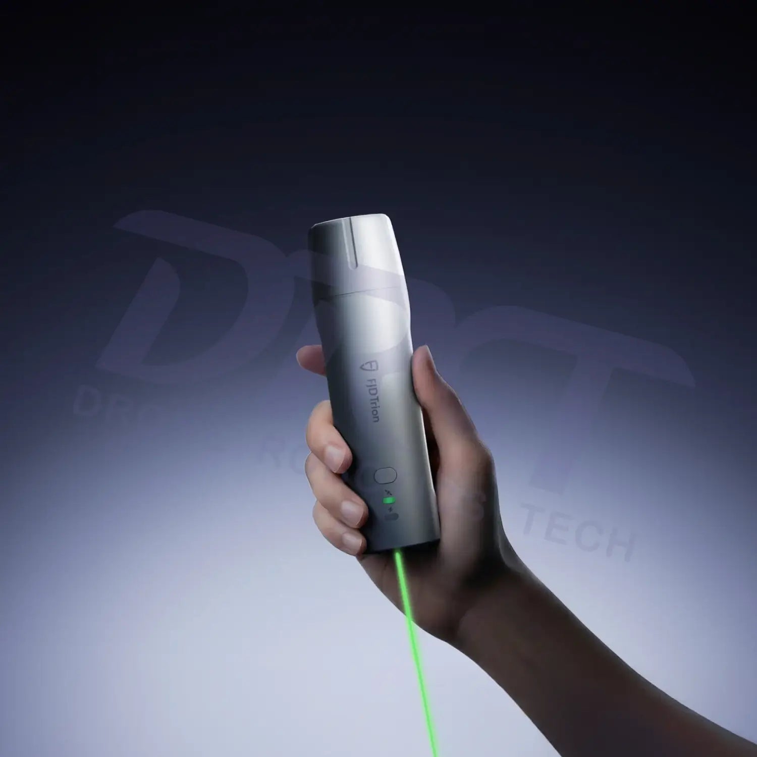
FJD Trion V4e & V4e Pro Mini RTK Receiver
Q0340023
Free shipping over $599.00
Money Back Guarantee
Pairs well with
FJD Trion V4e & V4e Pro Mini RTK Receiver
If you have any questions, you are always welcome to contact us. We'll get back to you as soon as possible, within 24 hours on weekdays.
-
Shipping Information
We offer reliable shipping across the United States. Orders over $599 qualify for free standard shipping.
Shipping options and estimated delivery times are shown at checkout and may vary by product and destination.
Products containing lithium-ion batteries may be subject to special shipping and carrier requirements.
For large equipment or enterprise orders, please contact our sales team for shipping assistance.
-
Customer Support
Need help choosing the right product, checking an order, or troubleshooting a product?
Our team can assist with product selection, order status, shipping, warranty, technical support, and general product questions.
Sales & Product Inquiries
Phone: +1 (888) 356-6818
Email: sales@droneroboticstec.comTechnical Support
+1 (888) 356-6818 Ext. 804 — Christopher
+1 (888) 356-6818 Ext. 806 — LucasWorking Hours
Mon–Fri: 9:00 AM–5:00 PM PST -
Contact Us
Have a question before placing an order?
Contact our sales team for product recommendations, availability, pricing, enterprise solutions, and bulk orders.
Sales Team
Phone: +1 (888) 356-6818
Email: sales@droneroboticstec.comFor enterprise, commercial, bulk, or dealer inquiries, we're happy to help you find the right solution.
Compact RTK GNSS Receivers for Efficient Field Surveying
FJD Trion V4e Series
Choose between the FJD Trion V4e and V4e Pro to match your surveying workflow. Both deliver centimeter-level GNSS RTK positioning in a compact 320 g design, while the V4e Pro adds IMU tilt compensation and integrated laser measurement for faster pole-free point collection.
One Series. Two Surveying Solutions.
The FJD Trion V4e Series combines high-precision GNSS positioning with a lightweight, field-ready design. The standard V4e provides a compact solution for accurate RTK mapping and data collection, while the V4e Pro adds advanced tilt and laser measurement capabilities for more demanding surveying tasks.
V4e vs. V4e Pro
| Feature | V4e | V4e Pro |
|---|---|---|
| GNSS Channels | 1,408 | 1,408 |
| RTK Accuracy | Centimeter-level | Centimeter-level |
| IMU Tilt Compensation | — | ✓ Up to 60° |
| Integrated Laser Measurement | — | ✓ |
| Weight | 320 g | 320 g |
| Battery Life | Up to 12 hours | Up to 12 hours |
| Protection | IP67 | IP67 |
STANDARD VERSION
FJD Trion V4e Mini RTK Receiver
The V4e provides a compact and efficient RTK GNSS solution for professionals who need accurate positioning without carrying a larger surveying receiver. With 1,408 GNSS channels and centimeter-level RTK positioning, it is designed for everyday mapping, field data collection, and precision positioning tasks.
Designed for Efficient RTK Mapping
The lightweight 320 g receiver is easy to carry throughout the workday. Its compact design, IP67 protection, and up to 12-hour battery life make it suitable for field environments where portability and reliable positioning are important.
- 1,408-channel GNSS receiver
- Centimeter-level RTK positioning
- Compact 320 g design
- Up to 12 hours of battery life
- IP67-rated protection
- Suitable for mapping and field data collection
PROFESSIONAL VERSION
FJD Trion V4e Pro Mini RTK Receiver
The V4e Pro builds on the V4e platform with integrated IMU tilt compensation and laser measurement. Instead of requiring the receiver to remain perfectly vertical over every point, the V4e Pro allows users to collect points at different angles, helping improve efficiency when surveying difficult or hard-to-reach locations.
IMU Tilt Compensation
Built-in IMU technology enables tilt-compensated surveying without requiring the receiver to remain perfectly upright. The V4e Pro supports measurement at angles of up to 60°, helping users collect points more efficiently in real-world field conditions.
3D error ≤ 2.5 cm
3D error ≤ 3.5 cm
Integrated Laser Measurement
The integrated green laser allows the V4e Pro to measure points without placing the receiver directly over the target. This pole-free workflow is especially useful for corners, edges, obstacles, and other points that may be difficult to access directly.
Maximum laser measuring range
Laser ranging accuracy
Class 2M laser
V4e PRO
Pole-Free Surveying for Hard-to-Reach Points
Combining RTK positioning, IMU tilt compensation, and integrated laser measurement, the V4e Pro provides a more flexible way to collect points where traditional pole-based measurement can be inconvenient.
Point & Measure
Aim toward the target point and collect measurement data without positioning the receiver directly over the point.
Measure at an Angle
Tilt compensation helps maintain efficient data collection when the receiver cannot be held perfectly vertical.
Reach Difficult Points
Laser measurement helps capture points around obstacles, edges, and other difficult-to-access locations.
High-Precision GNSS Performance
* RTK accuracy specifications are based on FJD Trion published specifications and may vary depending on satellite visibility, correction source, atmospheric conditions, baseline length, multipath, and field conditions.
Built for the Field
Both V4e versions are designed for professionals who need reliable positioning equipment that is easy to carry and operate throughout a working day.
320 g Lightweight Body
Compact enough to carry easily between measurement points and field sites.
Up to 12-Hour Runtime
Designed to support extended field work with a single charge.
IP67 Protection
Built to withstand dust and water exposure encountered in outdoor work.
1.2 m Drop Resistance
Designed to handle the demands of everyday field use.
Applications
Topographic Survey
Collect accurate field points for terrain and site mapping.
Road Surveying
Capture points along roads, edges, and other infrastructure.
Construction & BIM
Support site measurement, positioning, and field data collection.
Utilities & Public Works
Measure utility-related points and infrastructure in challenging field conditions.
Forestry & Agriculture
Support precision mapping and location-based field data collection.
GIS Data Collection
Build accurate spatial datasets for mapping and asset management workflows.
Technical Specifications
| GNSS Channels | 1,408 |
| RTK Accuracy - Horizontal | 0.8 cm + 1 ppm RMS |
| RTK Accuracy - Vertical | 1.5 cm + 1 ppm RMS |
| RTK Initialization | < 5 seconds |
| Initialization Reliability | > 99.9% |
| Data Update Rate | 1 / 2 / 5 / 10 / 20 Hz |
| IMU Tilt Compensation | V4e Pro: up to 60° |
| Laser Measurement | V4e Pro: 0.03–60 m |
| Laser Ranging Accuracy | ±3 mm |
| Battery | 5,000 mAh Li-ion |
| Battery Life | Up to 12 hours |
| Charging Time | ≤ 3 hours |
| Connectivity | Bluetooth 4.2, Wi-Fi 2.4 GHz |
| Dimensions | 182 × 53 × 53 mm |
| Weight | 320 g |
| Operating Temperature | -20°C to 60°C |
| Protection Rating | IP67 |
Choose the Right V4e for Your Workflow
V4e
A compact RTK GNSS receiver for professionals who primarily need accurate positioning and efficient field data collection.
Recommended for:
- GIS mapping
- Field data collection
- Agriculture mapping
- Basic RTK surveying
- Topographic mapping
ADVANCED WORKFLOW
V4e Pro
An advanced RTK GNSS receiver with IMU tilt compensation and integrated laser measurement for more flexible point collection.
Recommended for:
- Professional surveying
- Construction & BIM
- Utilities & public works
- Hard-to-reach point measurement
- Pole-free surveying workflows
Precision in a Compact Form
From everyday RTK mapping to advanced pole-free surveying, the FJD Trion V4e Series provides a compact solution designed around real-world field workflows.